
Community Resilience in the Pioneer Valley
The U.S. Census Bureau recently released a new set of community resilience indicators, which measure “the capacity of individuals and households to absorb, endure, and recover from the health, social, and economic impacts of a disaster such as a hurricane or pandemic.”
Just as COVID-19 has hit some of our communities harder than others, the ability to bounce back from the health and economic impacts of the deadly pandemic will also vary substantially. Knowing which people face the greatest challenges will help us to focus resources where they are most needed.
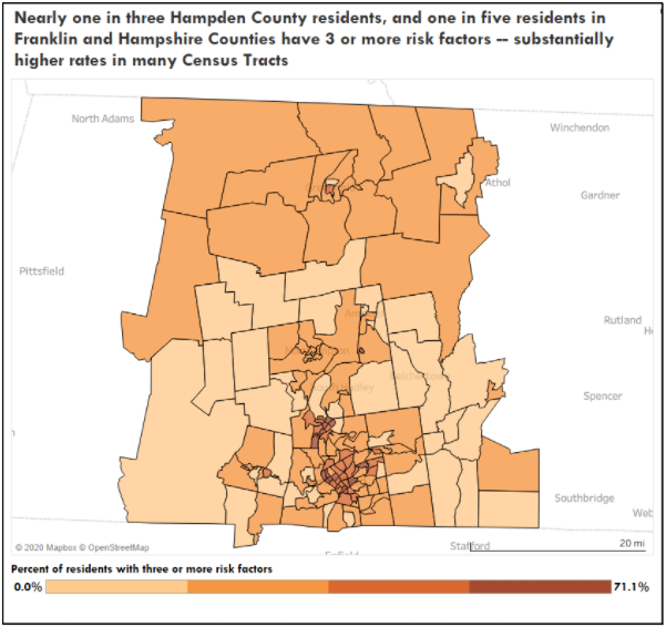
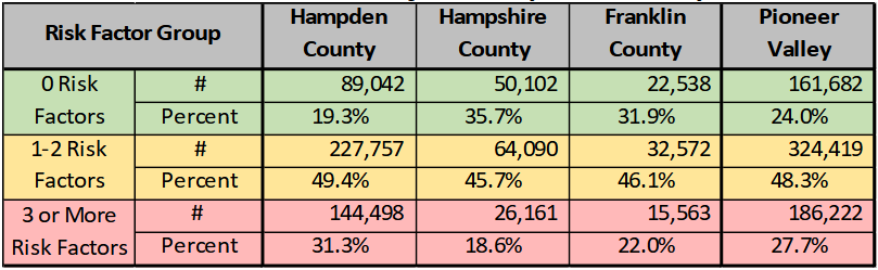
Across the Pioneer Valley (Franklin, Hampshire and Hampden Counties), more than one quarter of all residents (186,000 people) have three or more risk factors as identified by the US Census Bureau. About one in four (162,000) have no risk factors, while the balance, about half of residents in the Pioneer Valley, have one or two risk factors.
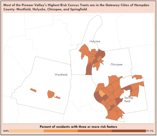
Of the 45 Census Tracts in the Pioneer Valley in which at least one in three residents have three or more risk factors, almost all fall within the boundaries of Hampden County’s four Gateway Cities – Westfield, Holyoke, Chicopee, and Springfield. (See Figure 2). Outside of Hampden County there are just four such tracts: three in Hampshire County (one in Amherst, and two in Northampton), and one in Franklin County (in Greenfield).
The Census Bureau methodology drills down at the Census Tract level, categorizing residents within each census tract according to the number of risk factors each person faces.
They identify a total of 11 risk factors attributable either to individuals (I) or to the household in which individuals live (HH):
- Income-to-Poverty Ratio (IPR) < 130, [i.e., household i
ncome is less than 130% of the Federal Poverty Level](HH). - Single or zero caregiver household –only one or no individuals living in the household who are 18-64 (HH).
- Crowding (a): Household is in a high-density Census tract (HH)
- Crowding (b): Unit-level crowding – persons per room over 0.75 (HH)
- Communications barrier –linguistically isolated or no one in the household with a high school diploma (HH)
- No employed persons (HH)
- Disability posing constraint to significant life activity (I)
- No health insurance coverage (I)
- Age>=65
- Serious heart condition (I)
- Diabetes (I)
- Emphysema or current asthma (I)
Comparing counties in Massachusetts, Hampden County has the second largest share of residents with three or more risk factors. Only Suffolk County has a greater share of residents with 3 or more risk factors, though Suffolk also distinguishes itself as the only county in Massachusetts with no residents having no risk factors. (By comparison, about one in five (19.3%) Hampden County residents have no risk factors).
A notable gap between Hampshire and Hampden Counties is evident in the risk factor data. While Hampden is “next to worst” in share of residents with three or more risk factors, Hampshire is “next to best”, with less than one in five (18.6%) having three or more risk factors. Only Nantucket County has a smaller share of residents with three or more risk factors. Franklin County falls in between, ranking 8th (at 22.0%) among Massachusetts’ 14 counties when ranked by share of the population with 3 or more risk factors.
As a certified Municipal Vulnerability Preparedness (MVP) provider, PVPC has staff who have been trained to provide technical assistance to communities working on vulnerability assessments. PVPC has worked with many communities in the past to help them build resilience, especially in the context of the challenges posed by climate change. In 2017, we partnered with the City of Springfield Office of Community Development to prepare Springfield’s Climate Action & Resilience Plan. This report uses an index that uses similar criteria to the Census Bureau risk factors. The “social vulnerability index”1 used in the Springfield report determines the vulnerability of residents to the harms associated with climate change, but most of the measures – like the Census Bureau’s risk factors – are applicable to a broad range of challenging situations.
While different tools highlight slightly different elements, those working with the communities of the PVR recognize similar patterns in each, with lower income neighborhoods that are disproportionately home to the PVR’s BIPOC (Black, Indigenous, and People of Color) community facing substantially greater vulnerability, whether to the effects of climate change, the deadly ravages of a global pandemic, the challenges of completing a decennial census, or the effects of an economy that continues to perpetuate income and wealth inequality on the basis of race and ethnicity.
The ongoing COVID-19 crisis should reinforce our awareness of two important facts. First is the fact that there are people in our communities who routinely face systemic challenges. Second is that their continued vulnerability threatens the overall well-being of all of us. By removing barriers to their success, we can build communities that are stronger, more equitable, and ultimately, more prosperous.
1 The social vulnerability index used in the Springfield resilience plan combines measures for: median home value, share of population over 65 years of age or under 5 years of age, gender (percent female), race (percent non-white), share Hispanic/Latino, share with limited English proficiency skills, percent living below the federal poverty level, percent of households lacking access to a motor vehicle, percent of housing units occupied by renters, and length of occupancy in neighborhood.